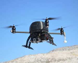
Leptron RDASS™ 1000
Quadcopter
The Rapidly Deployable Aerial Surveillance System (RDASS) Helicopter drone is a efficient platform for high or low altitude surveillance, photography and sensor deployment. The RDASS™ offers a fully featured flight system and military grade ground station. Battery propulsion means no power loss and quiet operation with easy field charging.
-
Full Featured Autopilot: Ground station with GPS Waypoints, Auto takeoff/landing, multi/single waypoints, altitude, velocity, heading, automated battery landing, flight terrain
-
Fast Response: In the air in less than 3 minutes
-
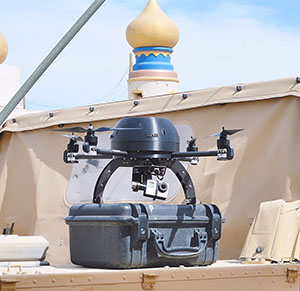
Ultimate Mobility: Single case for easy storage, total weight for all equipment is approximately 5 lbs.
-
Dual Mode: Both Ground Station and/or wireless controller for field user
-
Durability: Made from space age polymer, capable of winds of 35 mph
-
Endurance: Standard 20 minutes*
-
Flexible Camera Configurations: HD Video, FLIR, with wireless payload management for pan, tilt.
-
Harsh Weather: -10°F to 100°F and high altitude situations above 10,000 ft. without loss of thrust
-
Maintenance: Easy field service and optional expedited part replacement
*Atmospheric conditions and payload effect flight time.
| Standard | ||
| Rotor Diameters Width x Length Weight Engine Power Payload (Usable) Camera(s)/Sensors Service/Support Communications |
(4) x 11 in. 24.75" x 24.75" (tip to tip) 4.2 lbs. (empty) 4 Electric Brushless 1.7 lbs. (0.77 kg) Turret System, FLIR, HD Video/Still World Class training/support L, S and C Bands, Un-Encrypted Digital |
|
-
HD Video and Still Picture: Gyro stabilized 1080-4K video camera and still photos
-
Multi-Spectral: Single or Multi-band cameras
-
Infrared: 320-1080 IR cameras with optional dual HD camera
-
Custom: Ability to mount custom sensors (Gas Sniffers, HazMat Sensors, etc.)
-
Dual GPS Band (L1 and Glonass) for ultimate flight precision
-
GPS-based flight plans with flight plan templates
-
Auto-Takeoff and Landing
-
Lost communication with Return Home
-
Simple drag and drop user interface
-
Max and Min altitudes and custom controlled flight logic
-
Dual Flight Mode – The ability to use either a wireless controller or a GPS-based ground station
-
Full GPS Mode or No GPS Hold Mode
Adobe® Reader® is required
See what the RDASS™ 1000 can do
RDASS™ Overview: The Leptron RDASS™ offers simplicity with a single case for the helicopter drone, video, spare batteries and charger. The system offers stunning HD video and the video is from an RDASS taking video of both an Avenger and an RDASS in the air.
Leptron Utility Flights: The Leptron RDASS™ and Avenger™ are used to inspect utility lines. The systems offer both HD video and infrared camera systems. In addition, live view camera views allow ground personnel the ability to safely view potentially dangerous insulators and high tension power equipment.
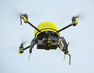
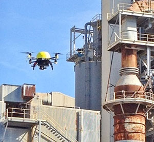
RDASS™ Industrial Use: The Leptron RDASS™ is used for industrial safety inspections, quarry blasting and topographic mapping. The system utilizes a full autopilot in high winds and extreme conditions with a live HD camera view.
RDASS™ Law Enforcement: The Leptron RDASS™ offers simplicity and portability for law enforcement. The system can be hand launched or landed. The system offers up close views and the ability to offer views for SWAT, accident scene reconstruction, search and rescue among many.
RDASS™ GoPro Zoom Capability: The Leptron RDASS™ is flown with the standard 3 MM GoPro camera and also a 16 MM Fixed zoom. The output illustrates that the standard 3 MM GoPro can view 2” letters from 10-20 meters and the 16 MM zoom can view 2” letters from 68 meters. With the GoPro editing software a 2 X digital zoom can be used to view 1" letters (at the 1:31 point in the video). The cameras are easily swappable and provide a significant view for animals, inspections and for remote surveillance.
RDASS™ High Definition: The Leptron RDASS™ HD offers the ability to view real time in High Definition. The system uses encrypted 720-1080p viewing with a 12” Daylight LDC or any other HDMI ready LCD. The range of the system is up to 1 mile.
RDASS™ Commercial: The RDASS 4 is used by an aerial photography company with a stabilized camera gimbal and GoPro 3. The system was flown in fully autonomous mode with GPS autopilot mode from a wireless controller and by a novice pilot. The system has a real time video system with a heads up display that indicates on-screen data for altitude, satellites, signal strength and battery strength.
RDASS™ Animal Management: The Leptron RDASS™ HD is used to aid in wildlife management at a game preserve. The system was flown with a full HD video system to view and count the animals real time. The RDASS was also flown with an iPad ground station in order to perform pre-built flight patterns.
RDASS™ Real Estate: The Leptron RDASS™ is used for aerial photography with a stabilized camera gimbal and GoPro to produce stunning HD photos and video. The simple and easy system can record views and viewpoints that were previously un-attainable.
RDASS™ Commercial: The RDASS™ 1000 is flown with a GoPro Hero 3 and stabilized video for an automotive car race. The system has a real time video system with a heads up display that indicates on-screen data for altitude, satellites, signal strength and battery strength.
RDASS™ Commercial: The RDASS uses a stabilized GoPro Hero 3 for video. The system can maintain 3D flight stability in winds up to 20MPH. The system shows the video output live on an LCD.