
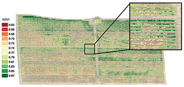
Vegetation Index (NDVI)
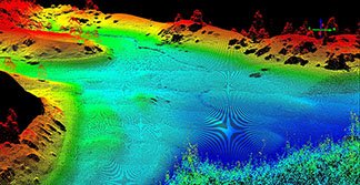
3D Photogrametry

Aerial Photography
Leptron Drone Services
Since 2006, Leptron Unmanned Aircraft Systems, Inc. has been utilizing sUAS (small Unmanned Aircraft System) technology to collect videography, photography, and remote sensor data as a professional service. The services we offer provide an aerial perspective tailored to your needs. Collectively, our team offers decades of manned and unmanned aviation experience.
 We Fly – We Process – We Deliver!
Real-Estate – Industrial – Utilities – Towers – Vegetation Management – Events
- FAA Approved
- Fully Insured
- Flying Commercial-grade sUAS Technology
- Industry Specific Remote Sensors
- Experienced Manned and Unmanned Pilots
 How It Works
- We help you develop the work scope
- We build the flight plan
- We collect aerial data
- We process and analyze the data
- We deliver the data
Our certified and experienced UAV pilots manage the process from end-to-end. Many of the processes involved with data processing is now automated which reduces time and expense. At sub-centimeter pixel resolution, Leptron leads the industry in precision.
Interested in learning how Leptron can provide your company or agency an aerial perspective?
Call Leptron at 800-722-2800 or
email your questions to info@leptron.com