 The GeoSwift UAS System
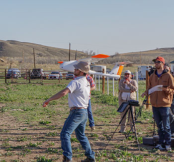
Available Flight Training
GeoSwift Mapper UAS
The GeoSwift Mapper UAS was designed as an advanced fully autonomous, yet simple to operate, survey and mapping unmanned aircraft system. The mission planning software is intuitive allowing operators to get up and flying quickly. Take-off is performed through a simple hand launch, and the landing algorithm features a robust and precise autonomous landing.
The GeoSwift Mapper UAS also features an interchangeable camera payload bay providing flexibility to suite your business's needs. Select from one or multiple cameras to produce professional outputs that include:
-
Orthomosaic
-
DSM (Digital Surface Model)
-
Topographic Map
-
3D Mesh With Texture
-
NDVI (Normalized Difference Vegetation Index)
-
Point Cloud
-
Thermal⁄IR
Aircraft Specifications |
||
| Platform Type Flight Time Area Covered Wing Span Operating Temperature Gross Takeoff Weight Maximum Airspeed Maximum Operational Winds Best Mapping Speed Stall Speed Maximum Rate of Climb Operational Ceiling Payload Operating Temperature Flight Management System |
Fixed Wing 1 hour 600 acres (900 with battery upgrade) 67.5" -5 to 100°F 6 lbs. 44 mph (20 m/s) 25 mph (11 m/s) 30 mph (13 m/s) 11 m/s 4.6 m/s 14,000' MSL RGB or Multispectral -5 to 100°F SwiftCore™ |
|
|
||
| Flight Management System Operating System Run Time Communication Frequency |
SwiftStation™, SwiftPilot™, and SwiftTab™ Android Tablet, 9.7" Display 4+ Hours 900mhz |
Ready-To-Fly Out Of The Box
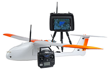
The GeoSwift Mapper UAS includes everything required for conducting mapping missions; aircraft, battery, ground station with tripod, tablet computer, field toolbox, carry case, control handset, and flight training.
Select from one or multiple camera and accessory options that suit your mapping needs:
|
Sony a6300 with Optional PPK/RTK (centimeter accuracy)
MicaSense RedEdge Multispectral
FLIR Vue Pro
|
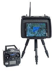 SwiftStation with Touch Screen Tablet and 6-Channel Transmitter |
|
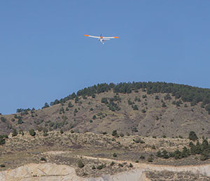
The GeoSwift Mapper UAS is ideal for survey and mapping applications offering a fully automated system with outstanding image quality and photogrammetric accuracy. Professionals use the GeoSwift Mapper to produce detailed modeling and site topography. Data collected is reliable, accurate and detailed. The GeoSwift Mapper is able to access areas that might be dangerous for human access. Challenging terrain is safely and quickly accessed with a drone. |
 |